COPPER RIDGE MASTER PLAN
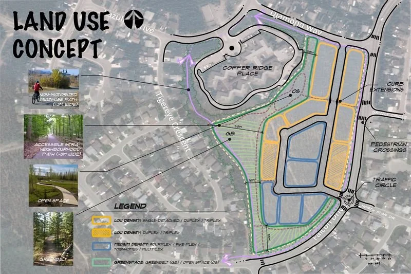
The Copper Ridge Development Area Land Use Concept illustrates the long-term vision for the site. Responding to the input received during the public engagement, the Land Use Plan promotes a mix of land uses, including residential, recreation, and community uses and a connected network of trails and open spaces. Land uses are carefully distributed, and future built forms are considered to minimize impacts on adjacent residential areas.
The site's northern portion is envisioned as lower-density residential with a mix of single-detached and duplex housing. Moving south, the built form transitions gradually in scale to a more intensive built form. A mix of duplex/triplex housing types is provided midblock, and a more intensive medium density wraps around the southern edge of the site. The greenspace plan is a centrepiece of this land use concept. A linear open space along Copper Ridge Place provides outdoor amenity spaces and facilitates safe connections to the future development area. With a mix of hard and softscape elements, the open space can accommodate a range of formal and informal activities.
Acknowledgment: In the spirit of respect, reciprocity, and truth, we acknowledge that we live, work and play on the Traditional Territory of the Ta’an Kwäch’än Council and Kwanlin Dün First Nation and all people who make the City of Whitehorse their homes and whose relationships with the land continue to this day.

